Sikkim is a wedge driven into the Himalaya. Bhutan lies to the east, the Tibet Autonomous Region of China to the north and northeast, Nepal to the west, and West Bengal to the south. It shares a border with exactly one Indian state — a distinction it holds alongside Meghalaya — and it sits close to the Siliguri Corridor, the narrow strip of Bengal that separates Nepal from Bangladesh.
The shape of the country
The state covers 7,096 square kilometres, making it India's second smallest by area and 27th by rank. It runs roughly 116 km north to south and 65 km east to west. The lowest point is 280 metres, on the Teesta; the highest is Kangchenjunga at 8,586 metres — the highest peak in India and the third highest on Earth. That is an 8,300-metre fall over a few dozen kilometres of horizontal distance, and it produces every climate zone from subtropical broadleaf forest to permanent ice in a single day's walk.
Two river systems organise the whole state. The Teesta rises in the Tibetan plateau near Tso Lhamo, cuts south through the length of Sikkim, and drains most of it. The Rangeet rises in the west and joins the Teesta near Jorethang, forming a natural boundary between the old western and southern administrative divisions. Almost every ridge, road and district boundary follows one of their tributaries. The terrain between them is steep enough that Sikkim has never had a road grid — it has a single north–south axis, National Highway 10, and everything else hangs off it.
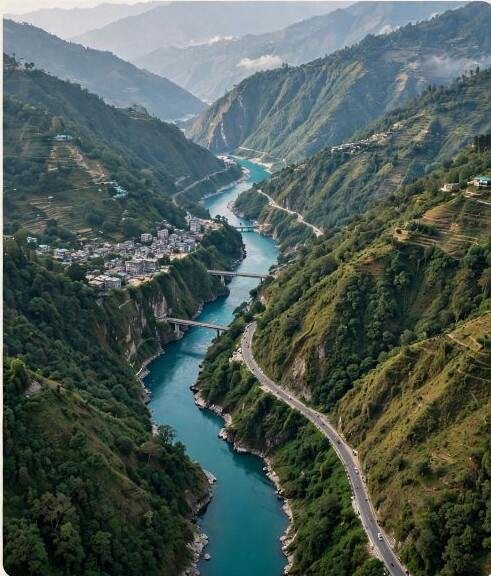
Three zones, stacked
Geographers usually divide Sikkim into three bands, and the division is useful because each has its own history.
- The low south — the Teesta and Rangeet valleys below about 1,000 m, subtropical and warm, where the tea gardens, cardamom and the state's road and rail links are. This is where most of the population and nearly all the agriculture sit.
- The middle belt — roughly 1,000 to 3,000 m, the terraced, forested slope country where Gangtok, Pelling, Namchi and most monasteries are. Temperate, wet, prone to landslides, and the zone in which Sikkimese settlement historically concentrated.
- The alpine north — above 3,000 m, opening onto the Tibetan plateau: Lachen, Lachung, Yumthang, Gurudongmar. Cold desert in places, snowbound for months, sparsely populated, and heavily restricted for visitors because it is a border zone.
Khangchendzonga National Park
The park covers 1,784 square kilometres — almost 35 percent of the state — across Mangan and Gyalshing districts, at elevations from 1,829 m to above 8,550 m. It was established in 1977 and inscribed as a UNESCO World Heritage Site in July 2016, at the 40th session of the World Heritage Committee, becoming India's first "mixed" site — recognised for both natural and cultural values.
The cultural half of that designation is unusual and worth pausing on. The park is not only a biodiversity reserve; it is a sacred landscape, containing lakes, caves and ridges that are central to Lepcha and Buddhist cosmology, including sites associated with Padmasambhava. UNESCO recognised the park as a lived religious geography, not merely a habitat.
The biodiversity is extraordinary by any measure: orchids, rhododendrons, the red panda, the blood pheasant, the snow leopard. It is also fragile and closely managed, with permits and designated routes.
Six districts
Sikkim was long organised into four districts — North, South, East and West. In 2021 those were reorganised into six. The 2011 figures below predate the reorganisation and are given for population only.
| District | Headquarters | Population (2011) | Area km² |
|---|---|---|---|
| Gangtok | Gangtok | 281,293 | 954 |
| Namchi | Namchi | 146,742 | 750 |
| Gyalshing | Geyzing | 136,299 | 1,166 |
| Pakyong | Pakyong | 74,583 | 404 |
| Mangan | Mangan | 43,354 | 4,226 |
| Soreng | Soreng | — | — |
The imbalance is the striking thing. Mangan is by far the largest district at 4,226 square kilometres and holds the fewest people, because most of it is high alpine and protected. Gangtok district is less than a quarter of that area and holds six times the population. Sikkim's demographic problem is not crowding; it is that the habitable part is small and getting fuller.
Landslides and the cost of building here
The same geology that makes Sikkim spectacular makes it dangerous. The rock is young, fractured and steep; the monsoon delivers enormous rainfall in a short season; and road-building cuts the slope's footing. Landslides are not exceptional events here, they are a seasonal condition.
This constrains everything. It limits road capacity, which limits trade. It raises the cost of construction and of maintaining the single highway. It makes hydropower attractive — the rivers fall fast — and simultaneously risky, since a glacial lake outburst or a slope failure upstream can destroy a project downstream. The outburst flood from South Lhonak Lake on 4 October 2023, which reached the Teesta III dam at Chungthang at midnight and destroyed it in minutes, demonstrated the whole problem in a single night.
Climate and what grows
Sikkim has five seasons in practice rather than four: winter, spring, summer, monsoon and autumn. The monsoon, from June to September, delivers the majority of annual rainfall and effectively closes the high routes. Autumn, from October, brings the clearest views of the mountain. Spring, from March, brings the rhododendrons and the orchid season.
Agriculture follows the altitude. Rice, cardamom and ginger in the valleys; maize, millet and potatoes on the middle slopes; and almost nothing above the tree line but pasture. The state's declaration as India's first fully organic state, achieved in 2015, was possible partly because its chemical-intensive agriculture was never large — the transition was less a conversion than a formalisation of existing practice.
Geography as constitution
Article 371F protects pre-1975 Sikkimese land law. That protection exists because the state is small, the habitable land is scarce, and the fear in 1975 was that unrestricted purchase would transfer the limited supply out of local hands. Geography, in other words, is written into the constitutional settlement.